Salmon Spawning area's now almost gone...

This 165 meter stretch is the largest area that was well used by salmon, evidence of where they have dug their redds can be seen by the changes in water colour and in the indents in the gravel on the left hand de watered edges which clearly show it has been used by spawning salmon in previous years, and there's a redd (nest) in the foreground - this is all going to dry up completely very soon with a net loss of salmon spawning area as a result of the illegal diversion.
Saturday 21st March 2015 - Update on the current state of Deep Creek
Went for another walk along Deep Creek to see how it was fairing. The water level in the main channel has dropped further, and at the diversion the channel has eroded out a lot deeper now taking about 95% of the flow, it really is just a matter of time before all the flow will be going down the diversion, the dry summer without any decent scouring flows is likely the only reason the above picture still has some water in it. A couple more reasonable freshes and that will be it...it will be dry after the winter I have no doubt of that
I found a little information in the Water Conservation Order that I thought may allow Ecan to get involved so had approached them to see if they would act on this. It taken a while for them to come to a decision which unfortunately doesn't help the stream
Ecan explained that since CSI F&G oppose getting the stream fixed, and since CSI F&G are the fisheries experts and the Govt entity with the statutory role to manage our fisheries, then Ecan were unlikely to go against their wishes...
I took pictures of more salmon spawning water that has already lost a lot of it's water flow and is shortly going to disappear altogether as it dries up;

Above is a close up of the top of the page picture to show the indentations caused by salmon excavating their redds in years gone by, the tussock line indicates the previous water level before the diversion. After a good spawning these ridges extend right across the stream in what is an extensive area of spawning gravels, they were so pronounced that you could use the mounds to cross the stream without getting too wet.

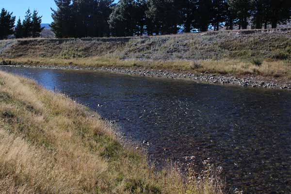
Another stretch that was well used; The shallow foreground area shows where the gravel has been dig up into mounds by past salmon spawning activity, they turn on their sides and use there tails to excavate their redds (nests). The indents in the gravel along the left bank are evidence of where more redds have been dug in the past
 This picture is from just below the top picture and shows more evidence of old redds where salmon have spawned previously

There are a number of other areas where there is evidence of past spawning usage like this, the gray area is slit that has settled in the bottom of their excavations.
All of the above areas are going to dry up and be lost forever because of an un consented diversion in a stream protected by a Water Conservation Order!
Not so clear in this one but this is another area salmon have used in the past, this part will not dry up completely as a side stream will maintain a small flow, whether that's enough for the salmon to still use it time will tell. The dry stones on the right bank show how much the flow has reduced.
The Diversion today;

This picture is of the diversion March 2015.
I estimate 95% of the flow is going down the left hand side whereas prior to the building of the illegal diversion bank 95% flowed down the right hand side to the right of where the picture is taken. The diverted flow has substantially eroded away the bed in this area and is now much lower, deeper than previously and is eroding back into the main stream bed. From the speed of the water it's clear it will continue to erode and shortly 100% of flow will be diverted
It will now clearly require a much larger intervention to rebuild the stream bank and return the stream to it's pre diversion state, with a likely much larger cost to perform an environmentally acceptable solution.
Summary:
I walked the whole stretch again, I stand behind my original views, as I predicted when I first reported this diversion to CSI F&G unless the diversion was repaired properly erosion would continue to erode the bank away until the whole flow goes the wrong way.
Also I have made very clear to CSI Fish and Game that this loss of flow will result in the loss of substantial areas of salmon spawning gravels, juvenile salmon habitat and trout habitat. With 95% of the flow going the wrong way this is now virtually a reality. The flow in the diversion channel is very fast, it offers little to fish, it's unlikely salmon can spawn there because of the water speed and there is next to no trout holding areas in my opinion, (which incidentally is that of an ex fishing guide with 12 years experience of finding fish for clients)
Ecan indicate they would be happy to revisit this if F&G change their mind
The sole and only reason this illegal diversion has not been fix is because CSI F&G have not been proactive in getting it fixed correctly in the first instance and now for reasons that remain vague won't support anyone else attempting to fix it, a delay that will have made it much harder to complete an environmentally sensitive restoration in this once superb back country stream
Read earlier reports on this issue
S Gerard